Total Pageviews

Thursday, October 25, 2012

Mountain Leader Training

Off on my Mountain Leader Training on Saturday morning with Thornbridge Outdoors. Five days in the Peak District and an overnight expedition in Snowdonia! Should be an interesting and challenging couple of days!

Well that's training completed and it was a challenge but brilliant in spite of the worst weather that The Peak District and Snowdonia could throw at us, including eight hours of solid rain on the Kinder Plateau and snow, hail and a torrential deluge on our overnight expedition on Snowdon!!


Friday, October 19, 2012

Some photos from walking trips in the past!

Given that I haven't been able to get out over the last two weeks I have fallen back on some reminiscing on walks completed in the past.......fun times!

In Bryce Canyon National Park, Utah


At the end of the Coast to Coast walk!


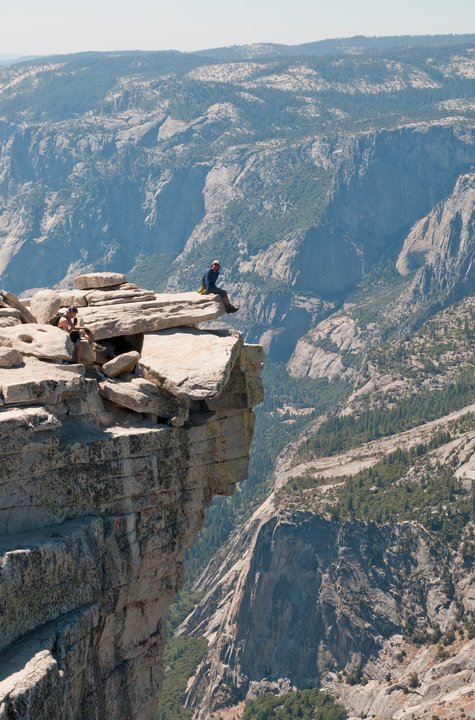
On top of Half Dome, Yosemite, California


On the Col Di Bos in the Italian Dolomites

Watendlath Beck Falls

On top of Snowdon during our Three Peaks Challenge

Cathedral Cove, Coromadel, New Zealand on a wet and wild day!

A walk in the French countryside near Duras


Campsite as Joshua Tree National Park ahead of Mammoth Peak hike

Jungle trekking in Fiji, near Pacific Harbour


Blue skies on top of Kinder Scout


Exploring The Pinnacles, Cervantes, Western Australia


Cooling down in Yanchep


Climber's window in St Olaf's Church, Wasdale Head


Wild campsite above Eel Tarn

Bryce Canyon from the Rim walk

Relaxing at Mariposa Grove

Finding some shade on the Half Dome trek

Walking near Gunung Brinchang in the Cameron Highlands, Malaysia

On Carlton Moor during my C2C


Taking on liquid at The Bluebell Inn, Ingleby Cross


Coast to Coast done!

Wednesday, October 10, 2012

The Fairfield Horseshoe

5.10.12
Walking with; Nobody


After a night at Elterwater YHA (great staff and breakfast) I headed over to Ambleside and parked up before following the A591 along to Rydal. The path climbed out of the village and past Rydal Mount, the historic home of Lakeland poet William Wordsworth. The walk up to Nab Scar zig zagged across the hillside but as I gained height the views across to Windermere began to open out and I knew I was going to be in for a cracking day. The route essentially follows a long ridge that sits high above the valleys on either side and from Nab Scar the path took me along to Heron Pike. At this stage the sun was still shining and though Fairfield itself remained in the cloud the rest of the horseshoe opened up in glorious sunshine. The views took in Rydal Beck,Windermere, Rydal Water, Grasmere (where Wordsworth is buried) and endless miles of rolling hills, tarns and rivers, not to mention the incredible dry stone walls on the slopes of Low and High Pike on the opposite side. The last few weeks have proved to me that the Lake District is the equal of anywhere in the world, I have sat and gazed at spectacular vistas in Yosemite, the Dolomites, the Sourhern Alps and the Pyrenees but when the Lakes gets it right, it can hold a candle to any of them.
I pressed onwards onto Great Rigg and as I descended ahead of the last slog onto Fairfield's cloud hidden summit the rain hit. It was the kind of wind driven rain that stings the cheeks and the gusts blowing across the ridge made for a wearying final few hundred metres. The summit was completely enveloped in cloud and could be quite disorientating without a compass, none the less I made the top and sought a little shelter from the wind behind a pile of rocks where I met a Scottish lady doing much the same thing! Heading East off the summit and ontowards Dove Crag the clouds cleared a little. The rest of the route follows an incredible dry stone wall for at least three miles, this helps with navigation but also acts as a reminder of the long standing nature of farming in the area that has shaped the landscape we see from this spectacular route. There were equally impressive examples on the steep solpes of Red Screes as the rocky path continued downhill through various peat bogs on it's long, slow way back to Ambleside. Eventually you emerge on the campus of the University of Cumbria before popping out almost opposite the excellent "The Golden Rule" pub http://goldenrule-ambleside.co.uk/ for a well earned pint of Robinson's Double Hop.
This route truly is a lakeland classic and combines sensational views with a satisfying amount of challenge. It also includes eight Wainwrights so is a good one for peak baggers/collectors!

To view the full album, please click on the link below;
https://www.facebook.com/#!/media/set/?id=718985691&tid=136991043086476&skipClustering=true&qn=556dfb3460222186986800a0059df563&success=17&failure=0&set=oa.281001475352098

Monday, October 8, 2012

A Langdale Round involving lots of Pikes and Stickles

4.10.12
Walking with; Nobody


Definition of PIKE

dialect English
: a mountain or hill having a peaked summit —used especially in place names

Origin of PIKE

Middle English, perhaps of Scandinavian origin; akin to Norwegian dialect pīk pointed mountain
First Known Use: 13th century

As I sat in Windermere Youth Hostel trying to drown out the din of a school group involved in noisily debating the merits of their quiz answers, I poured myself a glass of Jennings fine Cockerhoop beer and fell to reading, as one does in these situations, an ancient back edition of "TGO" or "Trail". A feature caught my eye on the differing names for mountains in the different parts of the UK and I read on intrigued by the world of Fells, Pikes and Tors. It hardened my resolve to visit Langdale the next morning and take in a round including both the Pikes of Blisco and Stickle!
   I parked at Blea Tarn and managed to time my setting off to perfectly coincide with a shower, but the views back to the Pike of Stickle were already spectacular. Striking off towards the Wrynose Pass the ground was sodden and water was running off the mountain but as I climbed the road I emerged out of cloud as I started to ascend the back of Blisco. The cloud inversion was spectacular, one of the best I've ever seen (up there with Alp D'Huez and the Queen Charlotte Track in NZ) and once I was through it the Pike of Blisco sat bathed in sunlight. The wind on the top was strong and chill so after a brief consultation with the map I left my fellow summmit baggers and descended to Red Tarn and then down, down and still further down in the shadow of Great Knott to the valley floor where my screaming knees were finally rested. I proceded into Mickleden and began the long, slow ascent up Stake Pass where I stopped for refuelling with a great view of Blisco across the valley. I continued on to Martcrag Moor, defined by Wainwright as demarcating the edge of the Central Fells and, today (and I suspect everyday), very heavy underfoot. As I tramped ever forward I was met with more rain and then a rainbow as I climbed up towards the Pike of Stickle. The rain had left the rock very greasy and a few would-be summiters were turning back but I slid and scrambled and as much by luck as judgement ended up alone on the top with views of my whole route so far and onto Windermere in the distance.
 
 Harrison Stickle awaited and then onwards downhill, with more creaking knees, to Stickle Tarn, sat in the magnificent shadow of Pavey Arc. The path down Stickle Ghyll showcased a pair of Raven and some beautiful, vibrant Rowan berries but was very slippery and I was glad to reach Langdale and the Dungeon Ghylls once more. Tempted as I was by a pint in either of the esteemed hotels I pressed on below Side Pike and back along the atmospheric shores of the tarn. Post walk refreshment had to wait until "The Britannia Inn" in Elterwater, but the wait was very well worth it!

To view the full photo album please click on the link below;
https://www.facebook.com/groups/136991043086476/#!/media/set/?set=oa.279299808855598&type=1

Tuesday, October 2, 2012

Lakelands Suggestions please

Hi folks, I am off to the Lakes for a couple of nights......forecast is pretty rotten but I am up for some serious walking. Looking for suggestions for the best walk in the Langdales? Also, a good walk out of Ambleside.....and finally, anything worth doing from Troutbeck or in that general neck of the woods? Any suggestions greatfully received. Thanks

Monday, October 1, 2012

The Todmorden Centenary Way

28.9.12
Walking with; Nobody


The good folk of Yorkshire must have done something to upset the almighty given the almost Biblical deluge that they'd been on the end of over the last week, none-the-less that was where I headed last week with the express intention of getting a few miles in my legs. I stayed in the Mankinholes YHA, a cosy hostel set in a 16th Century manor house http://www.yha.org.uk/hostel/mankinholes and a mere five minute walk from the excellent Top Brink Inn http://topbrink.com/ where photos of hardy looking Yorkshire farmers and horse brasses adorn the walls. Lumbutts, the neighbouring hamlet, has a magnificent Methodist chapel and John Wesley was once a regular visitor to the area where he preached to the locals.
The Todmorden Centenary Way is a 20 mile footpath created to commemorate the granting of Borough status to the area. With the walk in and out from Mankinholes and the occasional, ahem, detour, I reckon I ended the day with 23 miles under my belt which I think is probably my longest day of walking......there or thereabouts anyway! The walk up to Stoodley Pike set the tone for the rest of the day, muddy and wet underfoot and grey and squally overhead, yuck! I climbed up to Stoodley Pike and admired the view of cloud, cloud and a little more cloud! The monument on the Pike was completed in 1856 to commemorate the end of the Crimean War. It was designed by James Green and replaced a previous monument that was destroyed by lightening. It is certainly a spectacular spot and with the cloud and mist swirling around had a distinctly ghostly feel. I continued along The Pennine Way squelching through the puddles and moving in and out of cloud until I reached the vast expanse of Warland Reservoir where the rain set in.......so far, so good! Walking off the moor into Warland, I crossed the A6033 and past the Steanor Bottom Toll House before heading up the abandoned Calderbrook Road. The road had a kind of post-apocalyptic air to it as nature had taken hold and there were rabbits, squirrels and kestrels not to mention plenty of blackberries and wild roses.
The landscape round here is wild but man's stamp is very clear. Everywhere there is evidence of old mine workings, abandoned buildings, the inexorable column of electricity pylons and in the distance wind turbines slowly turning and dominating the landscape. None-the-less, the moorlands feel wild, exposed, barren and untamed and in 23 miles of walking I only met two other people, not something you could often say in the Lake District! I passed the Allescholes farms and headed up to the ruined farm at Ramsden at the South West end of Carberry Dam. The moors past here grew wilder and more mine workings and ruined buildings gave a real feeling of desolation. The wildlife clearly flourishes here and I saw Kestrels, Meadow Pippits and a flock of the very rare Twite, a real bonus! More moorland walking took me into Cornholme (the only place on the route with a pub as far as I could see) before another ascent led me over the Whirlaw Stones and opened up great views back across the valley to Stoodley Pike.
The last section of the walk took me down through Beech woodland and along the Rochdale canal before climbing through the woodland of Stoodley Glen and back to the villages of Harvelin Park and Stoodley. As I climbed back onto the Pennine Bridleway for the last mile back to Mankinholes the heavens opened for the last time and I arrived back at the hostel bedraggled, footsore but feeling very satisfied at the completion of a job well done.

To see the full photo album, please click on the link below;
https://www.facebook.com/#!/media/set/?set=oa.277191782399734&type=1