Total Pageviews

Tuesday, October 22, 2013

Cuba


Well, I was hoping to get out for a walk today, but I am feeling a bit under the weather, and I am off to Cuba on Thursday and there is plenty of packing to be done. Not sure if there'll be much walking on the island of Castro and Che, think it might be more cultural and historical, but we shall see......

Sunday, October 20, 2013

The Snake Path, Hayfield and Win Hill, Hope

10 and 16.10.13
Walking with; Nobody


Well after the highs and lows and mizzle and drizzle of Galloway I decided a couple of gentler routes with some more micro-nav thrown in was just what the Doctor ordered. The Snake Path runs out of Hayfield and was created in 1897 by the newly formed Peak and Northern Footpath Society, it leads away from the village and climbs up to the grouse shooting moorland of Middle Moor where the bright white shooting hut is an easily identifiable landmark. There were great views across to the Kinder Plateau but I decided to head in the opposite direction circumnavigating the low, bulky hillock of The Knott. The Grouse that had survived thus far were out in force and whilst the wind had teeth it was pleasant to be out and about.
I cut up Hollingworth Clough, a pretty path that involved much crossing and recrossing of the stream and a not inconsiderable amount of Bracken bashing. As the Clough opens out numerous tributaries stream down the hillsides and I picked one and followed it up onto The Knott where the wind buffeted me about as I admired Kinder once more and the views down to Hayfield and beyond. I followed the line of newly spruced up, and obviously recently used, Grouse buttes back down to the shooting hut before retracing my steps down into Hayfield. It was not by any stretch of the imagination a great adventure, but my day was infinitely better for having stirred my bones and headed out onto the moors. It also raised the thorny question of how I feel about Grouse shooting. I am a dedicated carnivore, I happily eat game and have tried all manner of exotic varieties over the years and yet I still feel somewhat uncomfortable about the whole process. I acknowledge that our moorland often looks the way it does because of the shoots and that they provide employment for local people and have close associations with tradition, and yet........it still doesn't sit quite right with me.
A week later and I was climbing slowly out of Hope, into the fog and onto Win Hill which remains one of my all time favourite peaks in the Peaks! The weather was pretty grim and the valley floor disappeared beneath me as I watched a Kestrel soaring on the currents, no need to hover today. I followed the ridgeline from Win Hill along the route of the old Roman Road to the Hope Cross, and then onwards to Blackley Clough. Another spot of bracken bashing took me out onto yet another Grouse moor, buttes, feeding stations and what I took to be numbered "beating" stations littered the top of Crookstone Out Moor. I'd planned to carry on up to Madwoman's Stones but by now the cloud had dropped even lower, the wind was blowing and the rain teeming down. Defeated, I trudged back towards Hope eventually dropping out of the cloud as I descended. A welcome cup of coffee at The Old Hall Hotel revived my flagging spirits but it definitely felt very Autumnal!

To view the full album please click on the link below;
https://www.facebook.com/photo.php?fbid=750280728321217&set=a.750279658321324.1073741836.597048676977757&type=3&theater 


Friday, October 11, 2013

Walking and wild camping in Galloway

6-8.10.13
Walking with; Nathan


When I find myself writing that my previous walking experience in Scotland was limited to a family holiday 25 years ago and a straight up and down "Three Peaks" experience on Ben Nevis I feel slightly ashamed and a bit of a fraud. It's like those Aussies who claim to have "done" England when they spent nine months living in a bed sit in Earl's Court or claiming to have visited Thailand when you had a three hour layover at Bangkok airport. So, there was a situation to be rectified and this was the occasion to rectify it and sneak in a couple of nights out in the hills as well.
Galloway seemed accessible for a short layover (although it was still a five hour drive from Manchester) and I met Nathan in Glen Trool. I'd killed a bit of time at the Visitor's Centre learning about the status of Galloway Forest as a "Dark Sky" park....sadly over the three days we were out we barely saw a glimpse of sky, let alone any of the spectacular starry skies the area is noted for. We set off along the Southern Upland Way, a long distance footpath that runs from coast to coast across Scotland. The Way here is basically a forestry road so it was easy underfoot but hardly the most scenic part of what is reported to be a spectacular path. We climbed out of the valley and skirted around the shores of Loch Dee, looking atmospheric with the low cloud shrouding the shores. At one stage we startled a deer which bounded across the path in front of us before disappearing at high speed into the depths of the forest. As the light began to fade we found ourselves looking for a site to pitch our tents but were continually thwarted by the saturated ground and Tussock Grass, it grew darker still and we eventually decided we'd no option other than to seek a spot in amongst the dense ranks of Pine Trees. Headtorches on we struck out into the serried ranks eventually finding a flattish hillock just wide enough for two tents. The accumulated matting of many years of pine needles made for a surprisingly comfy bed and not until I was awakened by the distant rumble of quarry vehicles, (which in my sleepy state I was convinced was a tree strimmer heading straight for our camp), was my sleep disturbed! 
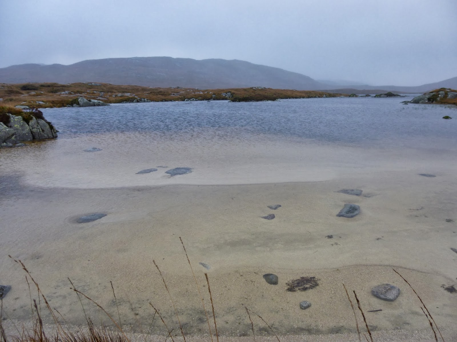
We climbed out of the forest and onto the tussocky slopes of Darrou, somewhere on those slopes I lost my main waterbottle (though thankfully I had a spare), I suspect it may be some time before anyone retrieves it, there was little sign the area sees much traffic. After much huffing and puffing we made the ridge line and continued forth in cloud and high winds over the peaks of Little Millyea, Meikle Millyea, Milldown, Millfire and eventually onto Corserine, the highest peak of the Rhinns of Kells. In spite of the fierce winds and inhospitable terrain we saw a Ring Ouzel and a Peregrine but no sign of other human life. Our map showed a forested descent, but once we hit the lower ridge for some superb views below the clouds it became clear to us that the slopes had recently been cleared, indeed it was here we saw our only other human over the three days driving a bulldozer on the recently denuded slopes. It was tough underfoot but we made the valley floor and after watching another deer made the long, slow ascent to the Nick of the Dungeon. I'd heard many words of praise for Loch Enoch (Icy loch) as a wild camping spot with it's white granite sand beaches and surrounding heights, but the clouds were dropping, the ground was saturated and it was needs must. We crawled into our tents, cooked up some tea and hunkered down for a wild night of wind and rain. It was the first time my Wild Country Hoolie tent had been tested, after the sad demise of the Vango Banshee, and it stood up admirably. It also has the advantage of being exceptionally spacious for a backpacking tent and I was glad of the extra room as I tried to air/dry off kit ahead of our last push up the Merrick the next morning.
Tuesday dawned grey, but as we picked our way round the loch shore we saw a single glimpse of sunshine and blue sky and a taste of how spectacular Loch Enoch might look under Summer skies. However, by the time we started to ascend Redstone Rig, it was back to cloud, mizzle and grey as the loch disappeared beneath us. Merrick, like Corserine, has a large grassy plateau as a summit and it was blowing a gale up there so we descended quickly down the tourist path over Benyellery and back down into the valley.
So, do I have the taste for Scottish adventure now? You bet. It was rough underfoot, wet and cloudy, but it felt remote and wild and I have never gone 48 hours in the Lakes or Snowdonia without bumping into another walker. My appetite has definitely been well and truly whetted!

To view the full photo album please click on the link below;
https://www.facebook.com/media/set/?set=a.743179995697957.1073741835.597048676977757&type=3 

Friday, October 4, 2013

Dog Bite

So there I was meandering around Lyme Park working on my navigation and map work and trying to better understand contours and re-entrants and the like. I was approaching "The Cage" when a little yappy Terrier type dog came hurtling towards me and circled me twice before biting me on the calf. I have to confess I am not a fan of dogs at the best of times but this has done little to improve my perception of them or the owners who allow them to run loose without any control. The owner of this miscreant mumbled an apology and mentioned something about "the wind gets her excited....." but it's not really on, is it?

Wednesday, October 2, 2013

Night Nav, three Dodds and Britain's lowest Marilyn!


25-27.9.13


Walking with; Nathan

One of the most intimidating aspects of the ML training is the night navigation, it is also one that in order to practice effectively it's good to have more than one of you. However I have found it tricky to find volunteers to clamber up onto a hillside in the dark and spent four hours bashing through wet bracken in the pursuit of ever smaller and more obscure features. Luckily Nathan is also a ML trainee and one who conveniently lives at the foot of High Rigg, a low, but suitably bumpy fell just outside Keswick. After an hour or two padding a canoe around Derwentwater with excellent views of Catbells and a stop on Herbert's Island named for a 7th Century Christian hermit, we donned headtorches and headed out onto the hill. Night nav requires a set of different skills with bearings, timing and pacing being the key and we spent four productive hours refining our techniques with varying degrees of success!
  The next morning with Nathan heading off to work I made my way over to St John's in the Vale and set off along the traverse of Wanthwaite Bank that led me under Threkeld Knotts and out onto the moorland below Clough Head. Apart from a farmer and sheepdog on a Quadbike, it was pretty quiet and I made my way to Calfhow Pike for beautiful views over Thirlmere and stretching across the Western Fells. High Rigg sat below me in the sunshine, looking a very different proposition in daylight! I climbed up to Great Dodd and then continued along the ridge to Watson's Dodd and Stybarrow Dodd with the sky blue above me and the sun on my face. The descent of Sticks Pass is a tough one on the knees but eventually aching and creaking I hit the valley floor and picked up the track that runs through the woodlands that skirt High Rigg before eventually I arrived at the church of St John's itself before making my way back to my car at Hill Top Farm.
  I spent the night at the YHA at Arnside, a magnificent old, rambling building that the YHA has sadly put up for sale. There was a beer festival at The Albion Inn in town and beautiful views across the deadly sands of the Estuary which were peppered with Herons, Curlews, Gulls and other waders. The next day a gentle dander along the promenade towards the woods of Arnside Knott provided more ornithological diversions and the woods themselves served up a couple of Nuthatches and some magnificent fungi. I eventually made it to the top of the Knott for fantastic vistas of the Lakeland peaks and the estuary, truly, truly stunning views! A small sign at the foot of the climb informed that the Knott is Britain's smallest Marilyn at 159m, a tick for a rather obscure box but an enjoyable way to complete a couple of days of varying walking!